Auction 087
Holy books, manuscripts, Judaica items, numismatics, coins
By Winner'S
Contact auction house
Feb 25, 2015
3 Shatner Center 1st Floor Givat Shaul Jerusalem, Israel
Terms of sale
View demo
The auction has ended
|
LOT 183:
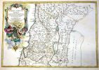
Giant Collection of Maps of the Holy Land. [63]. 16-19th Century
more...
|
|
|
Sold for: $3,800
Start price:
$
3,000
Estimated price :
$6000 - $8000
Buyer's Premium: 20%
VAT: 17%
On commission only
|
Giant Collection of Maps of the Holy Land. [63]. 16-19th Century
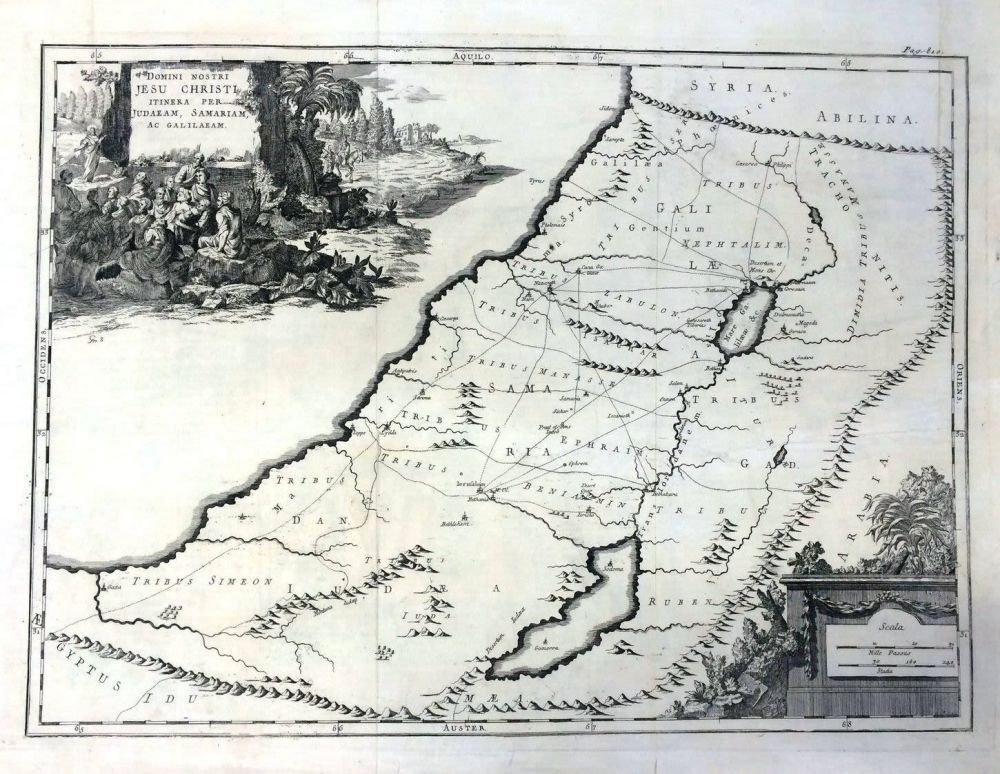
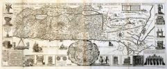
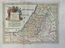
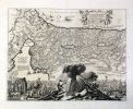
Impressive, large collection of maps of the Holy Land from different eras. 63 black and white maps, about half were colored at later times, generally in early times. The large majority of the maps are from the 16-19th century.
*regni davidici et salomonai, map of the Kingdom of David and Solomon. Nurnberg, 1739. * Tere de chanaan. Map of Canaan, and the tribe's encampment in the desert. Paris. * tabula in qua terra promissa. Map of the Promised Land in its twelve tribal divisions. Paris, 1679. * Map of the Holy Land in its tribal divisions. Paris, 1746. * carte de la terre sainte divisee. Map of the Holy Land in its tribal divisions. Paris. * de scriptio acurata terre promissa per sortes xii. Paris, 1646. * terre di canaan. Venice, 1785. * tabula secunda in qua terre promissa. Paris? 1662. * la terre sainte en six cartes. Booklet with six maps of the Holy Land. Paris, 1651. With two engravings. * The Holy Land in tribal divisions. Paris. * carte des douze tribus d'israel. Paris, 1771. * terra sancta tabula. 1763. * palastina sive terra sancta. Paris, 1646. * Map of the Holy Land and Syria. London-New York, 1850. *ancient palastine. London-New York, 1850. * Modern Palastine. London-New York, 1850. * Palastine sous le romains. Paris * Tribal divisions. Lyon, 1698. * israelitarum in deserto. Israelites' journeys in the desert. 18th century. * carte de la terre promise. 18th century. * nova description Judea. 17-18th century. * tribus simeon (map of Simon's portion). * Map of the Holy Land and Egypt. Dutch. * Map of the Holy Land, 1690. * palstine siue terra sancta. Paris, 1646. * carte de a palastine. Paris, 1833. * Map of the Holy Land and the Bank of the Jordan. Dutch. * terre des fils de chanaan. * Map of the Holy Land by Reland Adrian. Amsterdam c. 1715. * terra sancta palastina. * Map. Amsterdam. 18th century. * a plan of the land of canaan according to ezekiel's vision.
*duodecim tribu Israelis. Paris, 17-18th century. * cartre de la palastine. Paris. * Map of the Holy Land with many engravings. Paris 1771. * Map of the Holy Land divided into Judea and Israel and 12 tribes. Rome, 1679. * terre sainte d'israel. Engraving of a shekel coin from the era of the rebellion. Paris. * regnum salomonicu Paris, 1696. * Map of the Holy Land. Lutrecht, c. 1714. * tribus gad (gad's portion). * tribus manasse (Menashe's portion). * Map of the Holy Land with the tribal portions according to Ezekiel's vision. * Map of the Holy Land and the Sinai Desert, 1694. * Map of the Holy Land, 1782. * Map of the Holy Land, Venice 1779. * Map of the Holy Land 1651. * Map of the Holy Land. Paris, 1654. Map of the Holy Land, its tribes, their journeys and the Tabernacle. Paris, 1664. * Map of the Holy Land. Amsterdam? 1749. * Map of the Promised Land, in its tribal allotments, 17th century. * Map of the Holy Land during the birth of Christianity. * Map of Canaan in 1316 BC, tribal divisions. Padua, 1699. * Map of Canaan and the Holy Land. Paris, 1750. * The Holy Land in its tribal divisions. Homann Johann Baptist. Nurnberg, 1707. *General map of the Holy Land, Syria and the Western Bank of the Jordan. * Map of Canaan and the Holy Land. S. Robert. Paris, 1750. * Map of the Holy Land, Canaan, the journeys, and Tabernacle. Paris. *Map of the Holy Land during the era of the Judges. De la rue. * Map of the Holy Land, according to its tribes. Paris, 1709. * Map of the tribal divisions.
Various sizes. Varying conditions, most in fine-very fine condition. Copies of the maps are available on request.
